Click here for opening page    Welcome to WWW.MONIKIE.SCOT, from Scotland
Local InterestFamily History Items, FOR ALL!Newbigging Photos & 'Video'1000's of names of family history interest.Locally owned businessesLocal stories of days gone by, from W.D.C.Local Church Pages'Two-in-One' Church MagazineExtracts of historical interest from old books.Stirling AND Skirling surname interest & databaseContact the WebmasterMonikie War Memorial community hallThe Monikie Story - 'READ ALL ABOUT IT' - a book available from this website.A list of the pages on this site - pick some at random!Search THIS website, but read the advice first for best results.

Neville Chamberlain declares war on Germany in 1939
Neville Chamberlain
declares war on
Germany in 1939

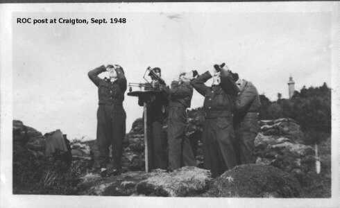
Ministry of Defence references at Monikie.

'Observations' by J. D.,
whose father served with the Royal Observer Corps.

(April 2002 - property sold - see below)


Military installations, south of Craigton, Monikie

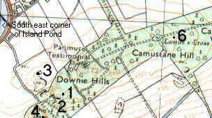
The map alongside is very small section of an Ordnance Survey Map and acknowledgement is given for its use.  The references to the Panmure Testimonial, and Camus Cross can be followed elsewhere on this site.  (Larger scale maps can be found HERE.)
The numbers refer to the text below.

1. - Site of the original Royal Observer Corps post - it was made of turf divot walls and was circular, with the "table" in the middle.  No protection against the elements.

2. - The position of the later post, just back from the edge of the quarry with the Panmure Testimonial in the background.  The photograph alongside is of the post,  was taken in September 1948.  My father is the one on the left, shielding his eyes with both hands as he scans the sky. The hut, removed by then, was positioned just behind him, a yard or two from the post wall.  It has been largely destroyed by the time this picture was taken but was originally chest high.  A clear picture of the 'table' from which they obtained bearing and angle of elevation; distance had to be estimated.

The walls of the post were of sand bags and there was also a small, wooden hut alongside.  This position was used for the rest of WWII.  In the hut, hanging by strings, were lots of models of allied and enemy aircraft to help the Observers with their aircraft recognition.  As a small boy, I coveted these models!  Also lots of cards, slightly smaller than postcard size, showing aircraft in plan from underneath, head on, and from the side.  The details of the aircraft were printed on the reverse of the cards.  I spent hours 'flashing' these cards at my father and other observers, testing them.  I was pretty good at aircraft recognition, too!

3. The site of the "bunker" referred to by Rev. Chisholm (elsewhere on this website).

4. The Downie Law is where the guns and 'looking-down' radar were situated.  Now it is the site of a mobile phone mast, but remains of the brick buildings (toilets, etc.) are still to be found.  In the quarry, below the post, were two huts for Royal Air Force personnel manning the Law site, and also a diesel generator for the power.  A power line ran from here to the site opposite the school (mentioned at the foot of this page).

5. Later!

6. The position two underground rooms where I fell into through the rotting roof, well after WWII.  Remnants of  use were found there, including the RAF personnel's favourite hairdressing - Brilliantine!  This installation was reputedly to be used by the Home Guard, operating as a 'resistance' force in the event of German invasion.

Alongside is a picture of my father in his R.O.C. uniform, obviously well after the war.

Regards, John.

ROC post in action.
David G. Dorward in R.O.C. uniform.
Former link to http:/www.scottishroc.org.uk which is now restricted access - WHY?

 If you served in the R.O.C. and would like to share your stories of life in the Corps or any other items of information, photographs, paperwork etc., they would be delighted to hear from you. To find out how you can help, please visit 'help the project page' or send your details and they'll get back to you!  If you have particular memories of the post mentioned above, the Webmaster would like to be informed, too.

July 2001 - Another part of Monikie military history has recently been 'buried'.  Until reconstruction, part of the eastmost driveway to the house, 'Fairlands', almost opposite Monikie Primary School, was formed by a large, flat, concrete base of a former WWII temporary hut construction, used by Royal Air Force personnel during WWII.  The concrete has now been completely covered by a new tarmac layer applied to the drive.

Readers can read about other features by using the Website Search Engine.

Look at many photographs of Panmure Estate HERE.

Part of Panmure Estate, including this facility, was sold in 2003 and you can read about it HERE.


LOCAL INTEREST ¤ FAMILY HISTORY INTEREST ¤ NEWBIGGING INTEREST ¤ ARLENE'S LISTS ¤ LOCAL BUSINESS ¤ 'DOWN THE AGES'
CHURCH PAGES ¤ CHURCH MAGAZINE ¤ OLD BOOK EXTRACTS ¤ STIRLING SURNAME ¤ MONIKIE MEMORIAL HALL ¤ 'THE MONIKIE STORY'
WEB PAGES LIST ¤ SEARCH THIS WEBSITE ¤ HOMEPAGE ¤ CONTACT & EMAIL

Please press the BACK BUTTON for your previous page.

The design and content of this page and website is the copyright of the webmaster (unless otherwise stated, freely surrendered, or in the public domain) and, where appropriate, may not be reproduced in any form without the permission of the webmaster.
This page was updated - 09 December, 2014