![]()
![]()
![]()
![]()
![]()
![]()
![]()
![]()
![]()
![]()
![]()
![]()
![]()
![]()
![]()
![]()
An extract from
by the late Nigel TranterTHE QUEEN'S SCOTLAND
The Eastern Counties
Published 1972 by Hodder
and Stoughton Ltd., St. Paul's House, Warwick Lane, London, EC4P 4AH
ISBN 0 340 16462 x
Permission to reproduce this extract has been requested from the publisher.
This rural parish lies eight miles north-east of Dundee and four north of Monifieth, and is readily identified, both on the ground and on the map, by the double Monikie Reservoirs of the Dundee Waterworks, of 73 and 46 acres, which, with a third one two miles to the north at Crombie, supply some 650 million gallons. The parish is medium-sized, of about 9000 acres, and contains the villages of Craigton and Newbigging. Monikie itself consists of two hamlets, the Kirkton and that at the former railway-station a mile to the west; plus another, reduced to a scatter of houses, at Guildy farther to the east. Two small ranges of hills divide the parish into three districts of differing character, traversed by the streams and dens of Monikie, Pitairlie and Buddon Burns.
The larger, Monikie, hamlet at the west end of the reservoirs, is quite an attractive place, with a surprisingly large granary, formerly a seed-crushing mill, to find in such a rural site, the works of the Panmure Trading Company, which dries and stores grain from a wide area, especially barley for the distilleries. The branch-line and former railway-station are closed. Half a mile to the north-west is the highly interesting Auchinleck or Affleck Castle. This is an excellent example of the sturdy and massive free-standing tower of the late 15th century, little altered, five storeys and 60 feet high, with corbelled parapet and two distinctly unusual square caphouses, the flat roofs of which form lofty watch-platforms. The first and second floors are vaulted, and the latter has a handsome pillared fireplace and a delightful little vaulted oratory, only seven feet square, with holy-water stoup, aumbry and pointed-arched window. Also a tiny laird's bedchamber above at half-floor level, with a private stair, and a squint-hole to look down unseen into the hall. The building is in the care of the Department of the Environment, and open to the public. The Auchinlecks or Afflecks of that Ilk were hereditary armour-bearers to the Earls of Crawford, and one did homage to Edward of England in 1306. The family provided a number of provosts for Dundee. The modern mansion stands near by, where the key is obtained. The last of the name to hold the lands disposed of them to one Robert Reid in the mid-17th century. Reid of Affleck was forfeited for his share in the Rising of 1745.
The village of Craigton is small, a scattered place but pleasant, lying at the other, east, end of the reservoirs. On the wooded Downie Hill to the south, within the large Panmure estate, are two features. One, highly obvious, is the tall chimney-like tower 105 feet high, rising out of curious small rustic chambers at ground level. This is known as the "Live and Let Live Monument", and was erected by the tenantry of Lord Panmure in 1839, in enduring testimony to the kindness and generosity of the laird, William Ramsay Maule, created 1st Lord Panmure after the forfeiture of his ancestor, the 4th Earl of Panmure, for his Jacobite activities. Seven counties can be seen from the parapet of the monument, which is a conspicuous landmark from the sea.
Near by on the same hill, to the east, in the centre of a driveway, is the Camus Stone, or Cross, an interesting and decorative Celtic Cross six feet high, ornamented with weather-worn sculptured figures, including a man flanked by two kneeling angels, and with two sets of priestly figures below. These are on the east face, the west face being badly worn. The sides have typical interlaced Celtic decoration. This is an unusual type of Celtic monument, with none of the Pictish symbols apparently, and wholly Christian, no doubt of later date than the more usual cross-slabs. It is alleged to mark the grave of a Danish Viking chief called Camus, slain in a great battle with Malcolm II in 1010. But circumstantial as this sounds, it is improbable that a pagan invader would be thus honoured with so fine a Christian monument. Much more probably it is connected with the early Celtic church. It is mentioned as the Cross of Cambuston in a deed of 1481; and there was a corn-mill of Cambuston in the barony of Downie, near by, in 1582. Which name is a corruption of which it is hard to say.
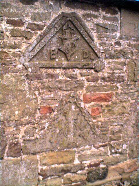
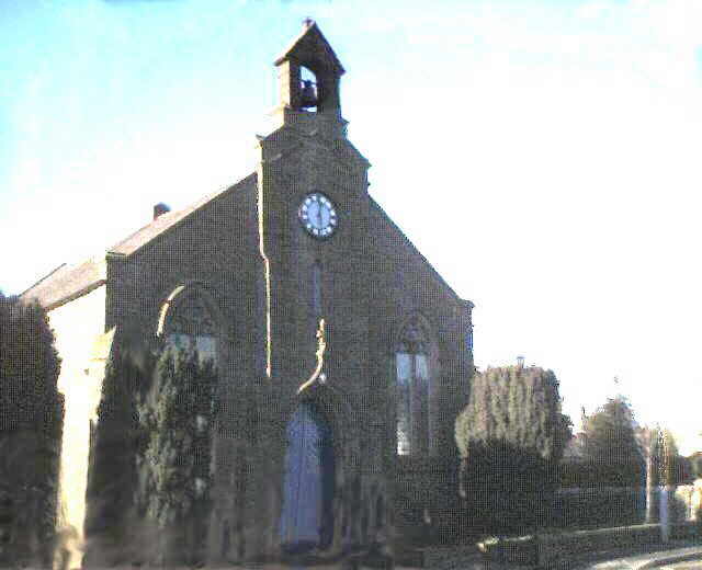
The Kirkton of Monikie, lying a mile to the east, has a parish church built in 1812, fairly plain. There are some old stones in the kirkyard, one dated 1656, and a mort-house. An interesting modern notice-board, beautifully carved in wood, with fine Celtic ornamentation, stands by the roadside, dated R.M. 1962 (R.M. was reputedly the Panmure Estate joiner - WM.). Built into the walling of a roadside cottage at the farm here are two dormer pediments, one dated 1587. These look as though they had come from a fortalice. Guildy lies half a mile to the north-east, a few houses, with the wooded Guildyden of the Monikie Burn to the south, part of the Panmure estate. There is much planted forestry hereabout, especially on Pitleavie Moor.
Newbigging is a larger village lying in the southern of the three divisions of the parish, erected in connection with the great quarries of this Omachie area which produced the famous Arbroath pavement stone and employed many workers. The quarries still function. Here there are a church and manse, formerly United Presbyterian. All this area was once part of the great thanedom and barony of Downie; and the farm of Old Downie, a mile to the north-east, was the site of its castle, on a green mound. It must have been an important place once, considering the number of subsidiary castles near by to support it. Duncan de Dunny is mentioned as early as 1254. Only a mile to the west is the farm of Pitairlie, where was another castle. One of its stones is built into the farm offices, dated 1631, with the initials of Alexander Lindsay. All the Downie properties were in Lindsay hands until the Maules got them in the mid-17th century. Denfind is another, half a mile to the north. Its fortalice has also disappeared. The name is alleged to have derived from the Fiend's Den near by, in which a monster or warlock, with an appetite for human flesh, is said to have dwelt, until apprehended and taken to Dundee, and burned "with his wife, bairns and family". This, with further circumstantial detail, from Lindsay of Pitscottie - but one wonders! A fourth castle in this same crowded vale of the Pitairlie Burn was at Ardestie, already mentioned under Monifieth, in connection with its Pictish weem or souterrain. This is more than a mile south of Newbigging. A number of carved stones from this castle are built into the farmhouse and cottages, one dated 1625 and another 1688. The Earls of Panmure themselves used to occupy Ardestie Castle at times. There was a chapel near by, with a well, but its site is unknown.
If all this recital of former castles seems tedious, it is an indication of the enormous number of such fortified houses formerly dotting the Scottish countryside. There are still a large number - but nothing to what must once have been the case. In the 16th and 17th centuries it was a land of castles indeed.
In the northern third of Monikie parish, with much moorland and high ground, there is less of detail - but splendid views, especially north over Strathmore. Up on Downie Moor, near Gallow Hill - this seems too far away, nearly four miles, to be the gallows hill of Downie Castle - there is a large cairn on the farm of Harecairn, survivor of many such, it is said, connected with some major battle of early days. It is pleasingly situated, near a dirt-road which leads up to some radar-masts, and on the edge of a wild moorland area of whins, heather and scattered Scots pines, an airy and attractive scene - and one which must represent what a great deal of Scotland looked like once. A mile north-eastwards, beside the former railway and near the farm of Skichen, is the wooded artificial mound on which are the scanty remains of a very ancient strength called Hynd Castle, history unknown. It appears once to have been an artificial motte rising out of marshland.
There is much more of historical interest on this website and you are advised to use the site search engine - keep your requests to one word for best results.
LOCAL
INTEREST ¤ FAMILY HISTORY INTEREST
¤ NEWBIGGING INTEREST ¤ ARLENE'S
LISTS ¤ LOCAL BUSINESS ¤ 'DOWN
THE AGES'
CHURCH PAGES ¤ CHURCH
MAGAZINE ¤ OLD BOOK EXTRACTS ¤ STIRLING
SURNAME ¤ MONIKIE MEMORIAL HALL ¤ 'THE
MONIKIE STORY'
WEB PAGES LIST ¤ SEARCH
THIS WEBSITE ¤ HOMEPAGE ¤ CONTACT
& EMAIL
Please press the BACK BUTTON for your previous page.