![]()
![]()
![]()
![]()
![]()
![]()
![]()
![]()
![]()
![]()
![]()
![]()
![]()
![]()
![]()
![]()
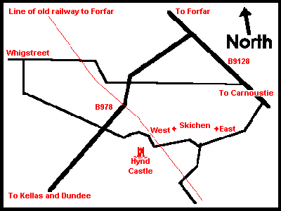 |
|
 |
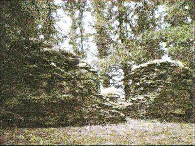 |
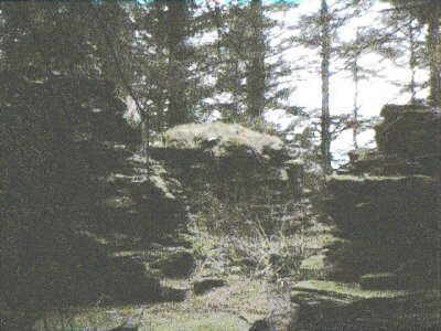
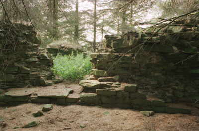
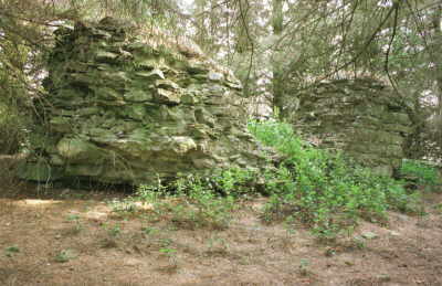
The lower two amateur photographs (use zoom for a bigger view) were taken on a rather dull, January 2000 day, in the middle of the thick clump of trees. From the webmaster's observations, the ruins of Hynd Castle consist of the remains of the four corners of the first few feet of the original building. It would appear that the castle had been a simple square tower, the sides being about 7 metres (23 feet) across overall (unmeasured). Such parts that remain are about 2 to 2.5 metres (6 to 8 feet) high and the walls at this level were nearly 2 metres thick. It can be surmised that the gap in the eastern wall was the position of the door, but the present gaps in the other three sides are unlikely to have been window openings so near to ground level. As happens to many ancient buildings, the stones of the tower seem to have been removed over the years and used for other purposes, probably nearby. There is no indication as to the likely height of the original building, but would likely to be about two or three storeys, which would give an excellent view of the surrounds owing to the elevated site. Could this building have been similar to the tower atop Kinpurnie Hill, part of the Sidlaw range, several miles to the west of Hynd Castle? There, the complete stonework still exists and the building is of greater dimensions (but see below!).
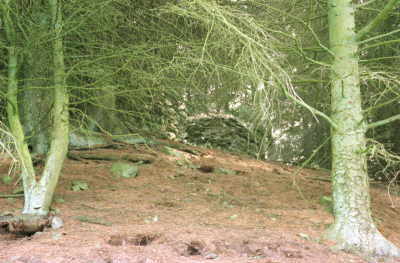
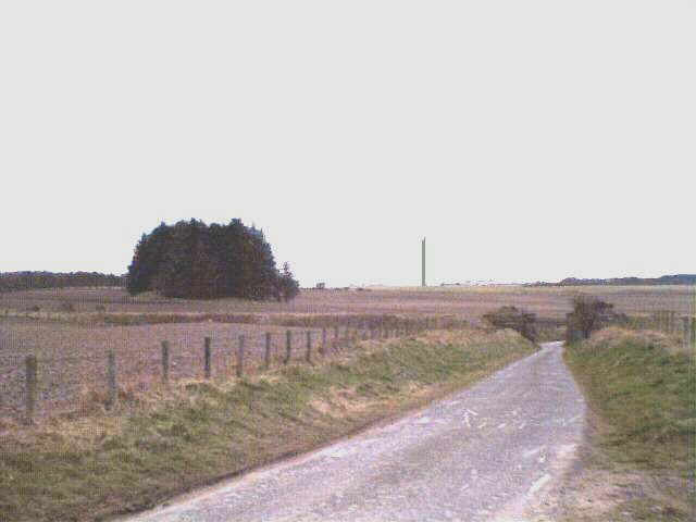
In the upper photograph, looking west from the Skichen direction, the castle ruins are situated on a hillock, or knoll, to the left, overall in a comparatively flat area of countryside. Now completely obscured from view, they can only be seen by climbing the hillock which is covered with 'unnatural' evergreen trees. Also in the photograph are the remains of the railway bridge on the Dundee - Broughty Ferry - Monikie - Forfar line; and far in the distance can be seen the transmitter mast at Balcalk, Tealing. The occupiers of the castle would have commanded a good view of the surrounding countryside - it is very unlikely that any trees would have been on the mound in its original form, as this would have reduced its defensive capabilities - assuming that to be its likely purpose. The hillock does not appear to be a natural feature.
Access to the hillock is over a muddy ploughed field, then 'dealing with' a barbed wire fence. Being private farmland, ask the farmer first if you wish to visit.
Further down for more, professional photographs.
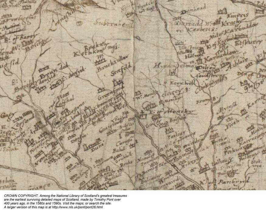
The castle appears on a very old 1500's map by Pont, a small section of which can be seen here.
Articles and comments below have been given to the webmaster regarding Hynd Castle, Monikie - more appear HERE and HERE. No opinion is given as to their veracity, but I hope they make interesting reading to any researcher.
|
Hynd Castle (from an article in the Dundee Courier) Regarding the query about Hynd Castle, Mr. Douglas Mitchell of Carnoustie has written to me. "Before moving to Carnoustie several years ago, I lived in Monikie for nearly 50 years, and have always been interested in its history and that of its surroundings," he says. 'As regards the query about Hynd Castle, I do not know when or by whom it was built, but it is shown on Ainslie's parish map of 1788, although in what condition it was then is not known. 'In George Cumming's Forfarshire Illustrated, published in 1843, he writes- 'There is a beautiful green mound, apparently artificial, which rises above the level of the Moss (Dilty Moss) to a height of 14 or 16 feet. A clump of trees covers the summit and encloses a ruin, the walls of which are about six feet in thickness and nearly double that measurement in height. The inside area of the base is a square of about 10 or 12 feet the side. There is a doorway in the side of the ruin and a window Space in each of the other sides'" "A very ancient strength" Continues Mr. Mitchell: "The Rev Douglas Chisholm, who was minister at Monikie for many years and wrote 'The Monikie Story' (1982 - republished 1998 - for sale from this website), recorded therein, 'that there was a small but thriving weaving community of at least five families at Hynd Castle prior to 1841, but no trace of this now remains.' "I hope the foregoing is of interest to the Scouts who found it during their recent trek." And on the same subject, Mrs. D. Hynd of Coupar Angus sends the following extract from Nigel Tranter's Eastern Counties (read it on this site). "Monikie, Craigtoun and Newbigging . . . beside the former railway and near the farms of Skichen is the wooded artificial mound on which are the scanty remains of a very ancient strength called Hynd Castle, history unknown. It appears once to have been an artificial motte rising out of marshland."
|
|
"The ruins of Hynd castle stand on a round, green mound, near the north-west point of this parish, close by the road from Dundee to Brechin, and a little to the west of the Dundee and Forfar Direct Railway. The mound appears to be artificial, and is not of much height. On the summit are a few trees surrounding ruinous walls, perhaps ten feet in height, and about half as many feet in thickness. The area they enclose is about twelve feet square, with a door on one side, and a window on each of the other three sides. The remains of Dilty Moss, one of the sources of the Kerbet, are at a short distance to the east of the castle. History is silent about this ruin, and it is not known when, by whom, or for what purpose it had been erected. It is too small to have been the residence of one of the lairds, and none but they had castellated dwellings. The castle was too near the great moss with the small ‘lake’ in its centre to have been a pleasant abode for any family of note. It had at one time been surrounded by water and a morass. The moss was exhausted and the ‘lake’ drained many years ago, and part of the site is now cultivated land." |
|
"Lying in a plantation of trees on the southern edge of agricultural ground to the south of the unclassified road between the B978 and A958, 1¼ miles south of Kirkbuddo. The shattered remains of the castle occupy the level summit of a low mound which may be a motte. The structure appears to have been a simple tower 9.1 metres square, possibly of the 14th or 15th century, with a splayed loop in its northern wall. It has been extensively plundered for stone, leaving only the massive angles of the unvaulted basement upstanding. There is no record of its early owners or history." |
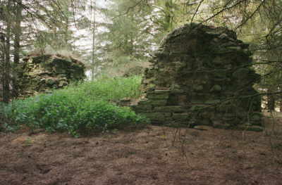
AUGUST 2000 - As a result of a small articles in both the 'Dundee Courier & Advertiser' and 'Guide & Gazette' newspapers I have been fortunate to have received several telephone calls regarding this castle and I am indebted to those persons who called. 'The Guide & Gazette' have also provided the following photographs. It seems that information is almost non-existent, but some of the guesses (educated or otherwise!) were most appreciated. A search by metal detectors in the area failed to find anything of interest. There is a suggestion that the building may once have been part of the 'policies' of a Roman Camp (see below) - the site of which is nearby to the north west, but not in Monikie parish, or the stone used to build the castle was 'quarried' from the Roman stone. Another suggestion is that the building was a prison for the local 'ne'er do wells'. Some of the submissions appear below and the reader is left to make any decisions as to the history of this building. One thing is certainly clear - the original building has provided a ready supply of stone for later periods!
The following four professional photographs are provided courtesy of "The Guide & Gazette", printed in Arbroath, thank you, Alan.
 |
 |
|
Dear Sir, The situation of this subject appears to be the key to its origins, viz., about half a mile to the west of the Roman access road from Carnoustie to Kirkbuddo. That is to find that road, draw a straight line from the Church at Barry to Kirkbuddo Farm and there you have it. There are many clues on the ground in this area to signify Roman in origin i.e. old tracks etc. and the fact that the area is now wooded should not be taken into account. What one must consider is the height of subject above ground, relative to other geographic features. Taking this as an example Hynd Castle is visible from both Kirkbuddo Farm (the Watchtower there) and that part of the main road at the highest point between Monikie and Carnoustie (The Buddon Road). Once this is accepted, any and everything can be seen in a new light. That is the source of water for travelling men (half mile to the east). Two miles from Kirkbuddo Camp and the Midway point to Carnoustie - where the One Hour stop would have been taken, etc. Any way, I would personally extrapolate any other likely geographic data from the first edition Ordnance Survey dated 1827 in black and white and at a scale of 1/10560. Original copies are held in the Scottish Map Library in Edinburgh. (Webmaster's note - One can also find such old maps on the O.S. Website at www.old-maps.co.uk ) The building of what is clearly a medieval watchtower there
has, in my view, no real significance regarding its original purpose. There are
other significant man-made hills of similar size in this area also and I would
draw your attention to the one lying to the south of Brechin. All of them have (
so I have read ) been noted as Roman in origin. The author of this piece has since, kindly carried out some research into this matter and provided a detailed article which can be found here. |
|
I kept a bit out of the Craigie Column (in the Dundee Courier) answering a
request for information about Hynd Castle some years back and it gave an answer by a Gordon Campbell of Kingoodie
who said that "where the farm of Old Downie now stands was the
site of the castle of the thanedom and barony of Downie. This is
about 5 miles to the south of Hynd Castle. The origins of the
Downie castle go back to at least the middle of the 13th century and
it is known that it had a number of subsidiary castles. Hynd
Castle may have been one of these. There is little to see now of
H.C. except the mound (probably an artificial motte) rising out of
farmland (which was almost certainly marsh when the castle was built.)
In 1848 however a George Cumming (writing in the Forfarshire
Illustrated) recorded that "the walls are 6 feet in thickness and
nearly double that measure in height. The inside area of the
base is a square. There is a doorway on one side of the ruin and
a window space in each of the other sides." A few miles NW
of Hynd Castle the remains of another ancient fortified dwelling can be seen
from the B9127. Marked on the map this one was a temporary Roman
camp measuring 2280 x 1080 ft and accommodating 10,000 men!" |
| My husband has been 'all over' the Hynd
Castle site and discounts totally the Roman theory, as did a book in the
1800's! Interestingly, there is a small castle of the same construction and dimensions in Orkney which was built by Danish invaders in the 1100's. M. Hynd. |
 |
 |
| A look at a 19th century book by Andrew
Jervise, " Memorials of Angus and The Mearns" written in
MDCCCLXI (1861) mentioned lochs drained in the last 60 or 80 years which
include Hyndcastle, Baikie and Rostineth (Restenneth) in Angus. It
mentions also the one time casting of peats at Dilty Moss to replace
earlier workings at the mosses of Hyndcastle and Carmyllie.
Whilst not germain to the Castle building, this ancillary information might give a little insight as to what was going on in the Hyndcastle area at one time. Donald |
| I really enjoyed seeing the information
you'd amassed about Hynd Castle and funnily enough I too began to wonder
if it wasn't a watching tower for checking the surrounding land.
It's funny there aren't papers or maps or references to early owners on
historical documents somewhere or other.
Do you know anything about Vayne Castle near
Tannadice, Redcastle at Lunan and the ruined chapel of St. Skeoch at
Boddin? Could you put out a request for information on these on
your website? There's a lot of ruins in Angus that little is known
about. It's good to know that there are others interested in your
information. |
| The tower on Kinpurnie Hill is the remains
of an observatory erected either in 19th or late 18th Century by the
owner of Belmont Castle, not the present building which was an
enlargement of the previous Castle, whose estate included Mill of
Newtyle [the original terminus of the Dundee & Newtyle Railway].
I used to have in my possession a book titled "Ancient Things in Angus" [and I am NOT in it !!!], which might throw some light on Hynd Castle. Basically, I would describe it as being the remnants of a motte, which were I understand quite common in Angus, originally having a wooden palisade on an artificially created earth mound, into which the natives could flee when the Vikings landed on our fair shores. There is one at Old Downie farm, and, of course, Red Castle at Lunan Bay is a stone structure [or at least remains of] which was built on a motte to replace one earlier. There is also a much smaller one at the south end of Lunan Bay, known as the Corbie Knowe, and Corbie was the old name for a raven, which is loosely connected with the Vikings. Now - disprove that lot ! J.O.
|
|
Extract from LAMB'S ANTIQUARIAN GLEANINGS
HYND CASTLE |
| I have been unable to get the book Ancient Things in
Angus discussed in my earlier message, but I have a reference in: Fife, Perthshire and Angus, Bruce Walker and Graham Ritchie - HMSO ISBN 0-11-495286-8 Page 101 - "Small towers survive on a number of sites. It is uncertain who the occupants were as towers often appear on estates already having a major house. Younger sons, superior tenants or dowagers appear to be the most likely inhabitants but as yet there is no substantiated explanation. Ballinshoe Tower, Angus (no. 51) is typical of this class, having an overall plan dimension similar to the six-storey Scotstarvit Tower but only rising to two-and-a-half storeys. Other examples may be seen at...; Hynd Castle (NO 504415), a very small ruin which caused doubts until some Welsh examples were examined... It is possible that buildings of this type were to be found in considerable numbers at the beginning of the agricultural improvements but that they were considered to be too small to be worth retaining and were demolished, any interesting stones being built into the new farmhouse or steading." This book also contains a small line on Redcastle. I'm not sure, but I think that this http://home.clara.net/rabpert/rdcastle.htm is the same castle. The only reference I have for St.Skeoch is for Dunninald or St.Skae. http://ossian.geo.ed.ac.uk/scotgaz/towns/townfirst4200.html holds a very small reference to Vayne castle. http://www.britarch.ac.uk/educate/ed9n.html
might give you a reference for the Welsh connection. Question: What is the origin of the surname Hynd? Answer: Hynd comes from the occupation - a 'hind'. In medieval English the word is likely to have been 'hine' with the 'd' being added later. Hynd, in Scotland, refers to a farm servant with a cottage on the farm. The hynd was formerly bound to supply a female field-worker known as a bondager. The oldest recorded references to the name (according to Black's Surnames of Scotland) connect it to Glasgow in the mid 15th century." R.J.L. - September 2001 |
|
Hello,
I have visited your wonderful web site on more than one occasion
hoping to see if anymore has been added about the mysterious Hynde
Castle that lies near Skichen Farm.
Can I just say that over the years I have done varied amounts of research to pursue my hobby of metal detecting and with a friend and my brothers we have just started to take another shot at trying to find anything of real historical significance around Hynde. Initially, years ago, we had a search over the site, but not on the monument itself, and didn't find a great deal as it is in the surrounding fields that should give up any unknown secrets as to what has been going on here. It's the fields that still interest us we also try to keep the local farmer and Museum informed if anything is found. We have not tried on the crown of the motte that the remains stand on, partly because of the fact that it is an ancient monument, and partly because it is quite dangerous with rabbit holes everywhere, not to mention the trees which seem to encase Hynde. Hopefully with the technology of the machines we now use we just might be able to bring to light some more of the secrets lying in the ground around the site. It was my understanding the Hynde Castle may have had a link in feudal times to local hangings, as there is the site of a gallows hill at Douglaswood Camp, and another mound at the bottom of the hill that may have been the traditional Court Hill, meaning that Hynde may have been a place to house a prisoner before execution. However, I was also told another story that Hynde may have been built on an islet or motte being surrounded by water. Now I feel that if this was the case, then during our field searches, something should have come up to support that idea and if it is Roman in origin, which I still think it is, and there was water all around then, I am still puzzled as to why there isn't a lot of evidence coming up yet. In reality the building that is Hynde was used for a purpose either, as some kind of signal tower, or storage building, and would have been used long after the original builders had gone Through the ages artefacts would have been lost - my feelings are that it was indeed built by the Romans as the thickness of the walls are similar to that of the walls of Roman buildings in England, and a similar sort of building mortar shows through in its construction. D.D., The Detectorist, September 2003 |
|
Hi, I am a history student at Aberdeen University who has
completed a
course on Scottish History giving me a basic understanding of general
trends. Based on what information people have said before in other
contributions, I
would guess that Hynd Castle was maybe put to a combination of uses
before its final ruin. I reckon before it was even made into a solid
structure it may have been put to use by the Romans as a camp/rest
point. The trees in the area, that is to say if there was any trees in
this area at the time, would have provided a timber source for any
wooden defence structures built on the mound.
I would now also like to comment on the walls, which are quite thick and similar to other fortified structures found across Scotland. Recently I visited Dunbar and the wall thickness of both Dunbar Castle and Hynd Castle and the construction of these walls look similar, (going by the photographs of Hynd Castle). This could therefore suggest that, as Dunbar Castle was built around 1070 c. at the beginning of the Scoto-Norman Age, Hynd Castle is also possibly Norman influenced. Indeed, Red Castle at Lunan Bay was built at the time of King William the Lion, who carried on the work of his predecessors, David I and Malcolm IV in granting Norman barons territories in the Scottish borders. This was a strategic alternative to making Scotland appear as a target for William the Conqueror's new regime in England. I digress here a little, but because these monarchs allowed the settlement of these Norman barons in the borders, castles sprung up all over Scotland, and Norman influence began to creep its way all over Scotland . Therefore, one could guess that the structure of Hynd Castle may have been built in the late 12th or early 13th century. Also, both Red Castle and Dunbar Castle were used as garrisons against the Vikings but it is not likely Hynd Castle served this purpose, unless the Vikings were able to make inroads on horseback or on foot further inland, as they had on occasion in England and Frankia. As to the uses of the Castle, one can only surmise. All previous suggestions in your other contributions seem to be feasible. A.J.S. June 2009 |
|
Apparently
the Earl of Panmure sold The
Historical Journal, 36,
3 (1993), pp. 543—576
[I
think BL refers to British Library] |
| On your webpage URL http://www.monikie.scot/hyndcastle.htm
you may wish to add my Flickr image gallery, taken 31st January 2015
which may be of interest to your readers. https://www.flickr.com/photos/54229500@N06/sets/72157648242603274/ Also my video at https://www.youtube.com/watch?v=MuB98AJfPAA Please use the images and video without fear of copyright issues. P. M. |
| . . . awaiting YOUR contribution . . . |
If you can supply any more information or even comment, preferably in the form of a small note or article as those above, the Webmaster would be grateful to receive this by email, please. Consideration will be given to adding your submission to this webpage and should be free of any copyright or other restrictions. The Webmaster reserves the right to edit submissions.
LOCAL
INTEREST ¤ FAMILY HISTORY INTEREST
¤ NEWBIGGING INTEREST ¤ ARLENE'S
LISTS ¤ LOCAL BUSINESS ¤ 'DOWN
THE AGES'
CHURCH PAGES ¤ CHURCH
MAGAZINE ¤ OLD BOOK EXTRACTS ¤ STIRLING
SURNAME ¤ MONIKIE MEMORIAL HALL ¤ 'THE
MONIKIE STORY'
WEB PAGES LIST ¤ SEARCH
THIS WEBSITE ¤ HOMEPAGE ¤ CONTACT
& EMAIL
Please press the BACK BUTTON for your previous page.